Day seven would be the longest of the trail, an exhausting 35.5-km hike from Furtwangen to Lenzkirch. I had a pretty good night’s sleep and set off at around 8:30. It had rained during the night, but there was an icy wind blowing and the forecast said it would be mostly dry until mid-afternoon, which turned out to be true.
I had a little trouble finding my way out of Furtwangen and missed the Mittelweg markings in the town. After around 500 metres of the yellow markings of another trail, I checked the guidebook and realized I was on the wrong side of the river. Fortunately, a simple left turn at that point returned me to the correct path which had Kalte Herberge at 7 km rather than at 10 on the yellow trail, which sounded much better to me, given the distance to cover that day.
The climb up to Kalte Herberge, where I would have spent the night if the inn hadn’t been fully booked, was relatively steady and pleasant, with a few steep sections. The higher I climbed, the better the weather, even with the strong, chilly wind. It was turning into a beautiful morning. Just before the Kalte Herberge, the Mittelweg met up with the Westweg again for a couple of kilometres and I found myself walking a path that I knew from one year ago. By the time I reached the open section of fields leading to the inn, the sky was completely clear.
Shortly after the Kalte Herberge inn, the Mittelweg veered off from the Westweg to head into the woods again rather than follow the road as the Westweg does. This marked the true beginning of day seven in the standard breakdown of the trail. I had already walked over 7 kilometres and now had another 24 at least before Lenzkirch. Or so the guidebook said…
From this point on, until the descent into Neustadt that afternoon, the path flirted with the 1,000-metre altitude mark, making its way over the heights along a steady, undulating track, a lot of which was on wide forest trails or narrow surfaced roads leading to the different farms in the areas cleared for agriculture. Just before the Hochberg inn, I took a wrong turn because someone had been messing around with the signpost at the intersection. Luckily, this time, I realize my mistake pretty quickly and soon returned to the trail.
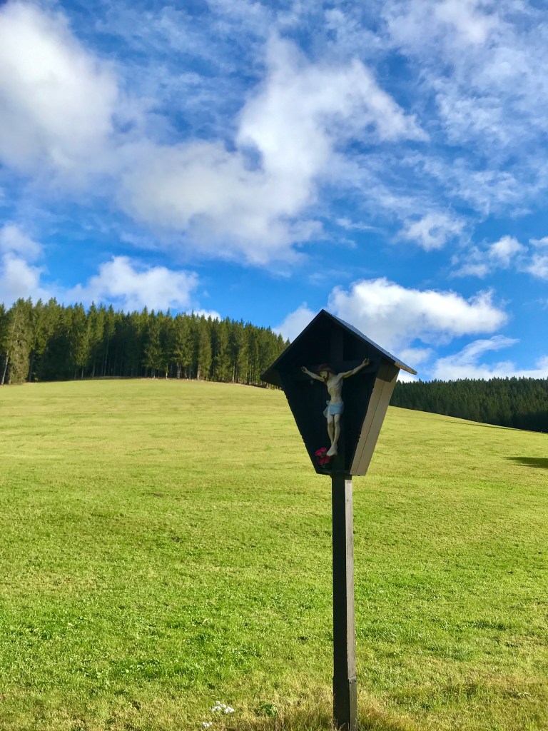
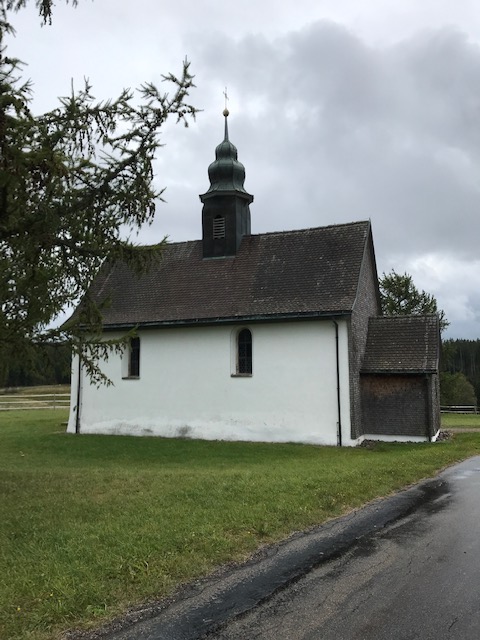
This was a very pleasant morning’s hike and I barely noticed the kilometres passing by. There were a lot of people out and about as it was the German Unity Day weekend (no doubt the reason why the Kalte Herberge inn had been fully booked). The views were fantastic on this very clear day (at one point, I was able to spot the Eiger, Mönch and Jungfrau in my favourite hiking ground of the Bernese Oberland, over 200 km away) and the cold wind was really invigorating. At one point, just after a pretty little chapel, the trail even turned “comical”: someone had placed amusing signs and installations all the way along until the next junction. There was even a joke board with a pen attached so that hikers could add their jokes to it. I didn’t understand all of them, but it made for an amusing kilometre or so. It ended with a mousetrap on a post that was marked, “This is the doorbell, press here and we’re bound to hear you”!
In this sunny weather, I again noticed something that I had remarked before on my different hikes at this time of year but never noted in this blog. In the Alps, the Black Forest and other uplands, you find the same pink flowers in summer. I have no idea what they are called, but a web search tells me that they could be rosebay willow herb, also known as fireweed or bombweed. They grow to a height of about one metre and are a spectacular deep pink colour in summer. And, in early autumn, when they turn to seed, they give off a powerful scent of wax, so waxy that it always carries me straight back to a batik workshop in Cirebon in northern Java where I bought two magnificent hand-drawn sarongs in 1991. Odd that a plant should have such a smell…
Another thing that struck me again on this Sunday when there were a lot of people on the trail was how well-behaved German dogs are. Contrary to their crotch-sniffing or rabidly barking French counterparts, most unleashed German dogs, on seeing a hiker coming towards them, will stop and wait for their owners to catch up. This makes for less stressful hiking than around home where we are often subjected to unfriendly (or overly friendly dogs) that the owners have trouble controlling.
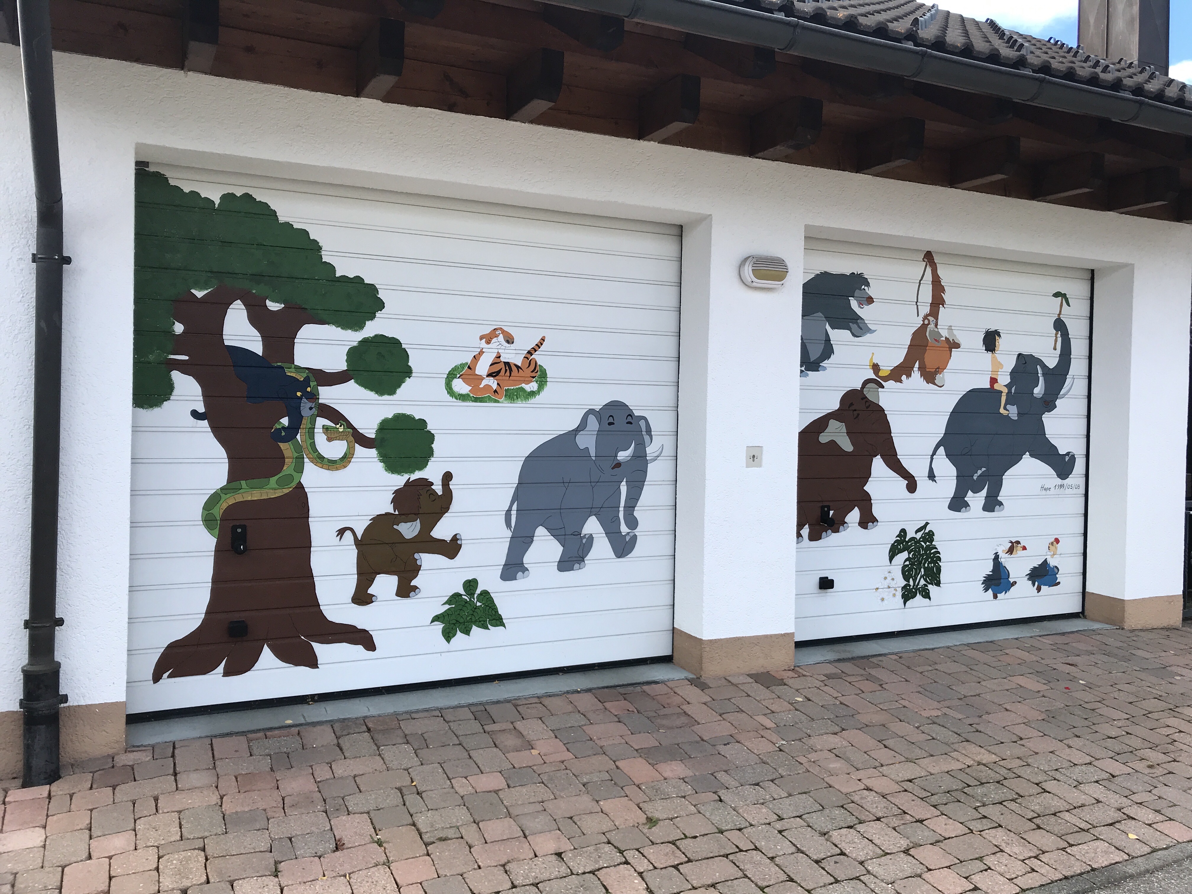
After the high-level trail, there was a very steep descent into Neustadt at 822 metres through a fairly select neighbourhood where I was surprised to come across the home of someone who was clearly as big a fan of Disney’s “The Jungle Book” as I am. The doors of the double garage were decorated with characters from the classic animated film. This sight cheered me up no end and made me forget my aching thigh muscles for a while.
In Neustadt, I found a café/bakery where I was able to rest for a while (after 24 km without really stopping for long), take the weight off my feet and have a whopping slice of cake with some fruit tea before embarking on the 360-metre ascent to the summit of the Hochfirst at 1190 metres, before an equivalent descent to Lenzkirch. It was a pretty stiff climb, but the path was nice and even, once again in thick woods.
At the summit, there was a viewing tower but the clouds had come in and it wasn’t worth climbing it. I stopped just long enough for a breather and to put on the pack cover in case it rained before setting off again, chatting to a friendly guy on the way down who was on a day hike and, once again, seemed impressed by the fact that I was doing the whole trail from start to finish.
About 1.5 km into the descent, the rain that had been threatening since the summit began to fall in earnest. I had to stop to get out the rain jacket but luckily it wasn’t heavy enough for the rain pants as well. The descent was as even and regular as the climb, but I was beginning to tire a little after 32 km or so. And a surprise awaited me when I finally arrived in Lenzkirch – my hotel was a good kilometre from the town centre! I have to look at the map more closely next time I’m booking a place.
When I finally made it there, the hotel was perfect, with a large room and a great restaurant where I had a terrific venison stew for dinner. I got chatting to a gentleman sitting at the next table who looked distant and almost depressed during his meal. He turned out to be pretty friendly, a German pensioner who was spending three weeks or so in Lenzkirch to convalesce after a stroke. He was on the mend but still had some way to go, the poor guy. When he found out I was British, I got the usual Brexit commiserations I’ve been getting for the last four years, but my German wasn’t up to explaining my rather intense feelings about the whole mess.
After the 35.5-km day, the eighth day on the trail would be one of the easiest, a 14-km hike from Lenzkirch to the world-famous Rothaus brewery that is said to produce one of the world’s best beers (and one of my favourites in any case). I woke to drizzle and the rain would persist until evening. As there was no rush to leave, I took the later breakfast rather than the early one. As in most places, it was very COVID-safe, with individual table service rather than a buffet and with more than enough to eat. Before leaving, I booked the last remaining place on the Rothaus brewery tour for that afternoon. And then, after getting into all my rain gear, I set off.
The day’s hike was fairly unremarkable. The trail out of Lenzkirch headed up hill for a long while, back up to 1100 metres at Auf der Höhe. It was mostly on wide forest tracks, with only a couple of hikers around after the weekend crowds. The drizzle continued, easing off at times, but creating enough mist to prevent me from getting what the guidebook referred to as a spectacular view of the Schluchsee lake below.
Just before Rothaus, the rain began to bucket down. I took shelter for a while at the Dürrenbühl chapel, whose simple exterior concealed a very ornate interior that was a big surprise in such a setting.

After the chapel, I covered the last kilometre or so to Rothaus at a fairly rapid pace so as to be done with the rain, mostly along the side of the road. The brewery turned out to be huge, covering a vast section of hillside at an altitude of 972 metres. As I approached, I found myself on a visitor’s trail, with information stations, around the outside of the different buildings. Because of the heavy rain, I didn’t really linger too long to take things in. Even so, through the windows, I got a glimpse of the gigantic copper brewing vats and the bottling line where not a lot seemed to be happening.
Thankfully, even though I arrived around 2 pm, my room was ready and waiting. It wasn’t in the main guesthouse but in another building about 5 to 10 minutes walk away. And what a room after a week of rather basic accommodation! Spacious, beautifully designed with lots of wood, a great shower, a sitting area, a Nespresso machine and a fridge stocked with free beer. Plus a view of the Bernese Oberland when the clouds cleared. Despite the luxuriousness, the price was very reasonable.

Unfortunately, due to COVID-19 restrictions, the brewery tour was a bit of a disappointment as the sanitary measures meant that our group was not allowed anywhere near the vats or bottling line. Moreover, it was the brewery rest day so we didn’t get to see the line at work from the viewing gallery (explaining why it was motionless when I passed earlier). Instead, we were shown a couple of films in a socially-distanced screening room before moving on to an interesting museum on the history of the brewery. I wasn’t able to understand everything as the tour was only in German, but I did get that they produce a huge amount of beer and export very little of it to other countries. Even within Germany, most of their production is consumed within the local region. I also managed to understand that the water used for the beer comes from a number of high-altitude springs around the sprawling site.
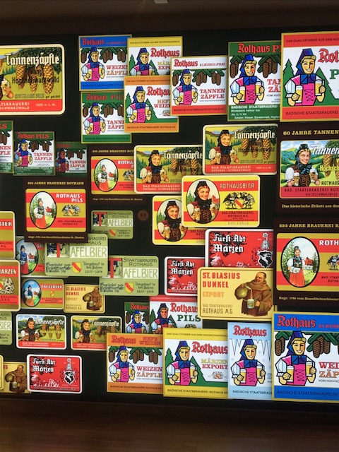
The tour ended with a tasting of a beer of my choice and a pretzel. I went for the new, slightly stronger Eiszäpfle which was as good as all of the other beers produced there. After a quick trip back to my room to drop off my buys from the souvenir shop, I went for dinner at the restaurant in the main hotel: a wonderfully warm and cozy setting despite its size where I had a great dinner before venturing back out into the rain to return to my room for a good night’s sleep.

The last day of the trail turned out to be the wettest. I woke to clear skies and a view of the Alps, but by the time I got to breakfast back in the main hotel, the clouds were already rolling in. It was yet another good breakfast and set me up for what would be another long day until dinner on the banks of the Rhine many hours later.
The final day’s hiking was mostly one long descent, but with a couple of surprises that were glossed over in the guidebook. There were very few people around today – I only saw a couple of other hikers on the trail and felt very much alone in the world until reaching more urban areas towards the end of the day.
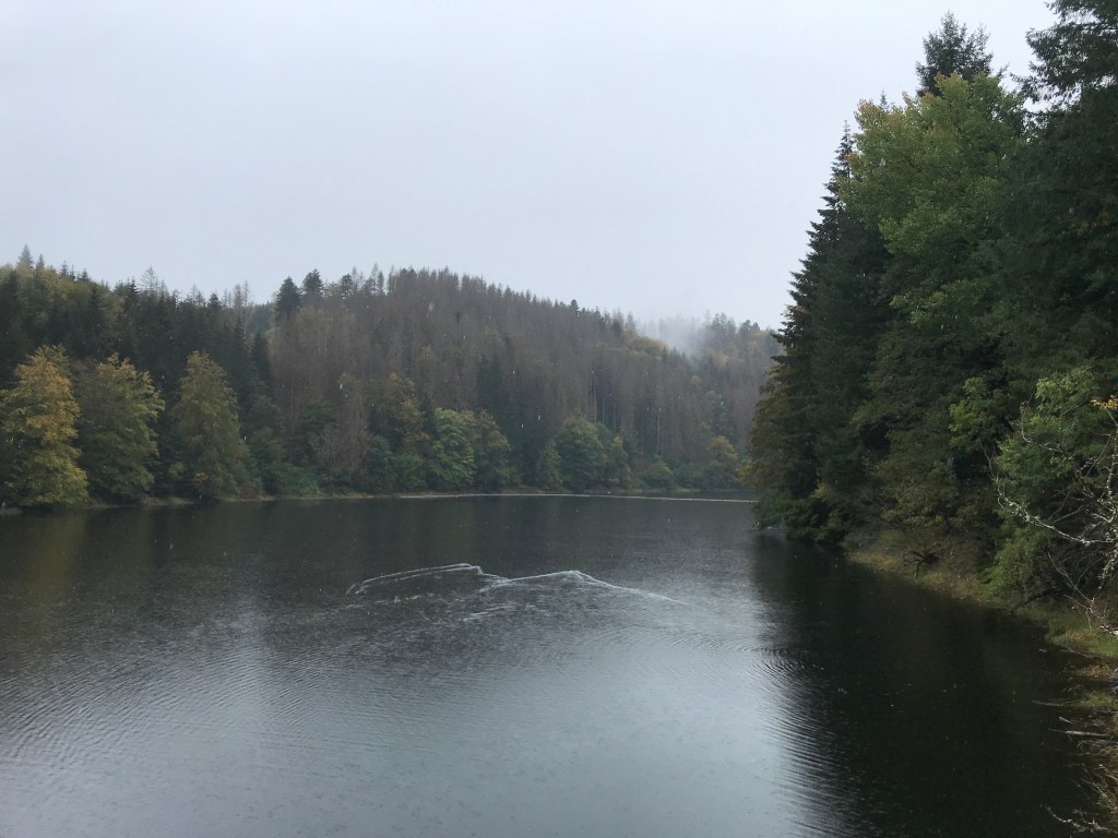
It wasn’t raining when I set off from the hotel after paying my bill, but by the time I reached the edge of the village about five minutes later, I had to stop to put on my rain jacket and cover the pack. The trail led steadily downhill through the silent woods, so silent that when a black squirrel bounded across the path in front of me, its footsteps sounded almost elephant-like! There was a lengthy stretch along a road (with hardly any cars), a beautiful old mill in the valley and an idyllic rest hut with a pretty water trough before I reached the Mettmastausee, a long and narrow lake set in the woods.

There was a fair bit of logging going on around the lake, making the track very muddy and rutted. The rain was also a lot heavier by this point, so I had to make a brief stop to put on my rain pants. The lake was very beautiful and mysterious in the mist and rain. There was a great view back along it from the dam at the end.
Shortly after the end of the lake, I crossed a road before following a pleasant, wide path. The forest around here was very thick and overgrown. The track itself was wide and regular, but it didn’t seem to be as well maintained or as frequented as on previous sections.
Then, after crossing another road and a bridge over the Schlücht river, the day’s surprises began. The guidebook simply mentioned a steep dirt track heading uphill. It didn’t say that the section was poorly maintained, with a number of trees lying across the trail that I had to climb over, or occasionally under, to reach the ridge at the top. Some of them were pretty sharp and dangerous where branches had snapped off. It was only a climb of 50 metres or so, but it was tough and I was glad to reach the top.

At least the views from up there were worth it. The pathway followed the very edge of the cliffs, with plunging views to the road below as clouds of mist drifted upwards. It was very enjoyable, with frequent, spectacular viewpoints. Despite the tough climb up, I was starting to think that this was perhaps one of the nicest days on the trail, along with the fourth day in the mysterious woods with the old border stones.

However, the day had more unpleasant surprises in store. After a steep descent on a barely visible track from the final viewpoint on the cliffs, followed by a regular ascent on a broad path, there was a horrifically unstable descent back down to the valley on a very narrow track where every stone seem to object to having my foot come to rest on it. At times, it felt worse than anything I encountered on the Costa Brava trail which is the stoniest I have come across so far. It was a relief to reach the valley and know that this tricky stretch was behind me.
I had hoped to stop for a bite to eat in Witznau as I had already been walking for over four hours non-stop by then, but the inn mentioned in the guidebook was closed and looked as if it had been shut down long ago. I no longer had any cereal bars left at this point and there wasn’t a single shop in the tiny village, so the only solution was to carry on and hope to find something to eat further on.
There was a fairly steep climb along the road out of Witznau before the trail veered off into the woods again. On entering the woods, I slipped and fell in a patch of mud. It wasn’t serious but it showed me that I’d have to take more care on the wet terrain. Due to the lack of detail on the maps in the Rother guides, I had very little idea of what was in store for me. The trail through the woods turned out to be very narrow and muddy as it followed the side of a steep slope. The guide did say that hikers needed to be sure-footed and not suffer from vertigo on this stretch, and that the steep ascents and descents could be hard on the knees. However, it did not say that the trail for most of the section was about 30 centimetres wide, with fixed cables installed from time to time. I don’t know if it was the lack of food or tiredness but, at one point, just after a section with cables, I set my foot down awkwardly on a rocky step, lost my balance and fell into a gully full of fallen branches. I was about a metre below the path, caught up in the branches and more than a little shaken. After a moment to take stock of the situation, I decided my walking poles were more of a hindrance than a help so I tossed them back up onto the path. Then I grabbed a branch to try to lift myself up. Snap! The wood was long dead and broke easily. I slid down another half-metre. The second branch I tried to use also snapped, but at least it didn’t result in my slipping any further down the gully. I managed to stay calm – I’d seen on the map that I wasn’t too far from a road, I had my phone in my pocket and I could easily call for help and say where I was if need be. But, as I wasn’t injured, I calmly tested the branches around me, finding a couple of steady roots to rest my feet on and a rock to use to haul myself up. I finally crawled back onto the narrow path, using the fixed cable for the final lift. I stayed there for a while on all fours, cursing myself, the narrow track, the rain, the guidebook and the closed inn back in Witznau. I then got to my feet, made my way gingerly over the spot where I had slipped and sat down on a tree stump for ten minutes or so to recover.

On setting off again, I think I must have still been a little shaken because, on finishing this narrow section, I missed a crucial marker and was forced to backtrack after going about 500 metres out of my way and winding up in a boggy clearing with no paths leading from it. I was very hungry and tired by this point (I’d been walking about six hours without a break). I was over the moon when the trail finally emerged onto a road that I followed before veering off onto a track leading to a village in the valley below. “Food at last,” I was thinking. But, unfortunately, the only bar/restaurant was closed for the day.
As I was crossing the very residential village of Gurtweil, an apple tree at the side of the path finally provided me with a little sustenance to keep me going. A very tart but crisp apple that I ate on a bench in the drizzle overlooking Gurtweil as cars sped by on the road behind me. The trail continued for a while along this busy road (very unpleasant after days of forest tracks with peaceful villages and small towns) before heading into the woods again. After crossing the road once more, the trail continued along the side of the Waldshut cemetery, a huge, beautifully peaceful spot with wandering paths and plenty of trees. Not bad as a final resting place!
After the cemetery, the trail passed a pretty chapel in the woods and then finally, below, I caught my first glimpse of the Rhine and the railway line leading to the station in Waldshut, the end of the Mittelweg. The rain began to fall in earnest again at this point and I didn’t linger on the way down to the mighty river.

I arrived at the station at around 5 pm, after eight hours and 34 km. It had been a tough final day, with a few tricky sections. But the feeling of achievement was as great as ever. I had another long-distance trail under my belt, my second of the three Black Forest north-south paths, and, despite my two falls and the lack of food, I felt on top of the world. The sign at the start of the trail in Pforzheim had given the total distance as 233 km, but I had walked a total of 249 km in the nine days. The Mittelweg hadn’t been as atmospheric and spectacular as the Westweg, but it had provided me with a different view of the Black Forest with its many farms and clearings, taken me to some pretty villages and towns, and allowed me to spend a night at the Rothaus brewery.
As I hadn’t been able to find a decent place to stay in Waldshut, I travelled about 15 minutes by train to the pretty town of Laufenburg on the banks of the Rhine. This was a great little spot with a beautiful old town and a bridge over the river to Switzerland. I could easily have gone to have dinner on the pretty Swiss bank but, on the way from the station to my hotel, I spotted a Greek place just by the bridge on the German side. When the hotel receptionist confirmed that it was a good place to eat, my mind was made up. A generous helping of gyros with lots of grilled vegetables more than made up for the lack of food since breakfast.
After a terrific night’s sleep, I took a train home early the next morning via Basel and Karlsruhe, arriving in Paris at 2:30 pm and home at around 4 pm. Roll on next year when I’ll tackle the Ostweg to complete my Black Forest hat-trick!

Thanks for sharing your experience of hiking the Mittelweg. I’m planning to hike it next year and your blog will be an invaluable reference. Thanks again!
LikeLike
Hi Peter,
Thanks for your comments. If I can be of help in any way, please get in touch – iburley@orange.fr
I also hiked the Ostweg and the Schluchtensteig in May/June this year, but haven’t written those up yet.
All the best,
Ian
LikeLike
Thanks, Ian. I hope you’ll write up your subsequent journeys – I am eager to read about them. Thanks again and happy trails.
LikeLike