On this third day, from Moselkern, I’ll be combining two relatively short stages of the trail (13 km and 14 km) to the village of Niederfell, just across the river from the town of Kobern-Gondorf. There will be around 1000 metres to climb in the course of the day, with 1000 to descend too as I’ll be staying in a river village as usual.
At breakfast, I spot a few other hikers for once – a couple who were in the same hotel in Karden the day before and, surprisingly, the young couple I saw on the first day. I expected the latter to be way ahead of me by now, but they too must have stayed in Karden or nearby like me. After wishing them all a pleasant day’s hiking, I set off while they’re still eating breakfast.
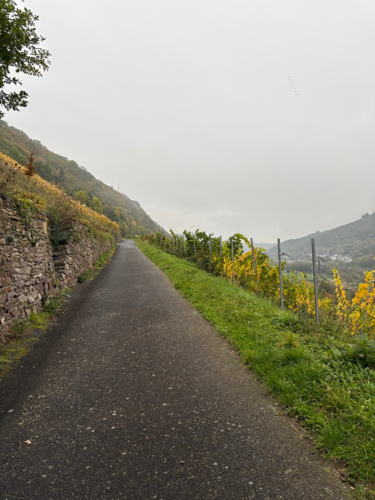
It’s another misty morning, but there is no rain forecast, and, as usual, the day begins with a climb. The trail heads up gently along a narrow road through the vineyards.
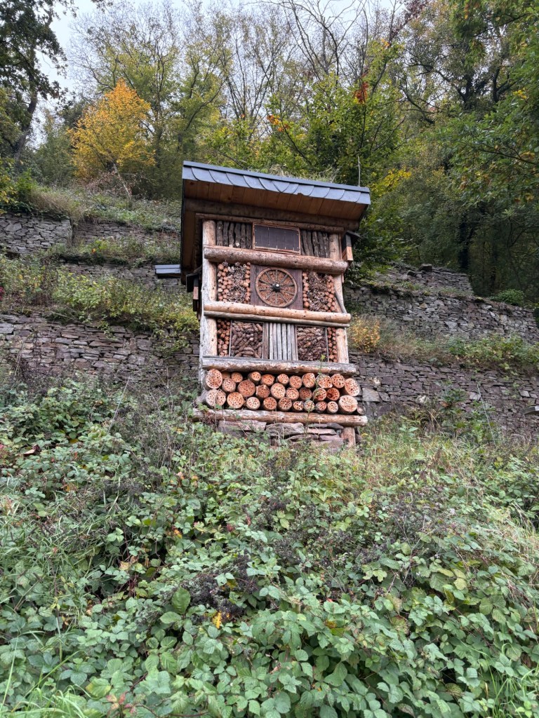
As I go, I spot a large “insect hotel”. There have been quite a few of these in the different vineyards that I have crossed since Monday and they are clearly there to encourage biodiversity in the vineyards. They are often fairly big, some with bird-boxes or roosting boxes for bats attached to the side.
After a kilometre or so, the trail leaves the narrow road for what the Germans charmingly call a Zickzack, a pathway that zigzags steeply up the hillside. It ascends rapidly and leads to a road that I follow as far as a small chapel where I then take a track across farmland to the small village of Lasserg. There’s a large church in the village with an intriguing gallery and a stamp box for pilgrims on the way to Compostella. The Moselsteig can also be walked by pilgrims who then pick up the 2,971-kilometre trail from Berlin to Compostella in Trier. Last year, we met a guy who was spending two weeks and heading down along the Moselle valley in France along the pilgrim route. I have seen very few markers for the pilgrim trail so far, but they will be more frequent over the next few days.

From Lasserg, the trail heads downhill across farmland, woods and vineyards to Hatzenport. The Moselsteig here follows a local trail, a Traumpfad, which translates as a “dream path”, and the path is indeed a dream to walk on as the morning mist gradually begins to lift and the sun tries to break through the clouds (without much success). All the same, the terrain remains pretty damp underfoot.
On reaching the outskirts of Hatzenport, there’s a Moselsteig warning sign concerning the next 300 metres of trail, that are described as a kletterpfad, which means there’ll be climbing with fixed cables and, according to the guidebook, ladders. There’s a way to avoid it by following the road to the railway bridge where the tricky section ends. Given the still damp conditions at this point and not wishing to slip on a ladder when I’m on my own, I chicken out and follow the road. All the same, I get my share of kletterpfad on the climb back up into the vineyards after the railway bridge as part of it has fixed cables.

For the second climb of the day, the trail takes me back up into the vineyards above Haztenport. It’s a shorter climb than the previous ones and not at all difficult apart from the initial cabled section.

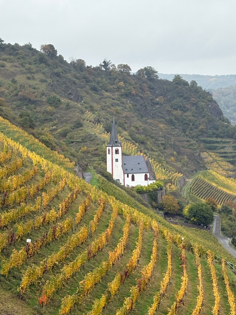
I soon find myself in the midst of the golden autumn vineyards, with fine views of the St Johannis church that stands above Hatzenport.
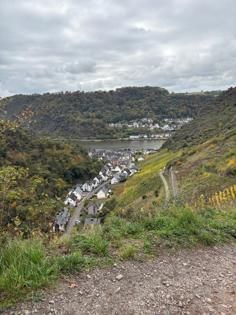
The trail remains high above the church as it makes its way to Rabenlay, a promontory above a bend in the Moselle between Hatzenport and Löf, the end of today’s first stage where I’ll be crossing the bridge to the opposite bank. From this promontory, it’s possible to follow a short cut down into Löf and save about 1.5 km, rather than take the trail that heads up into more agricultural land before descending to the village and its bridge after a fairly meandering route. Given the long day and the distance to cover, I opt for the short cut.
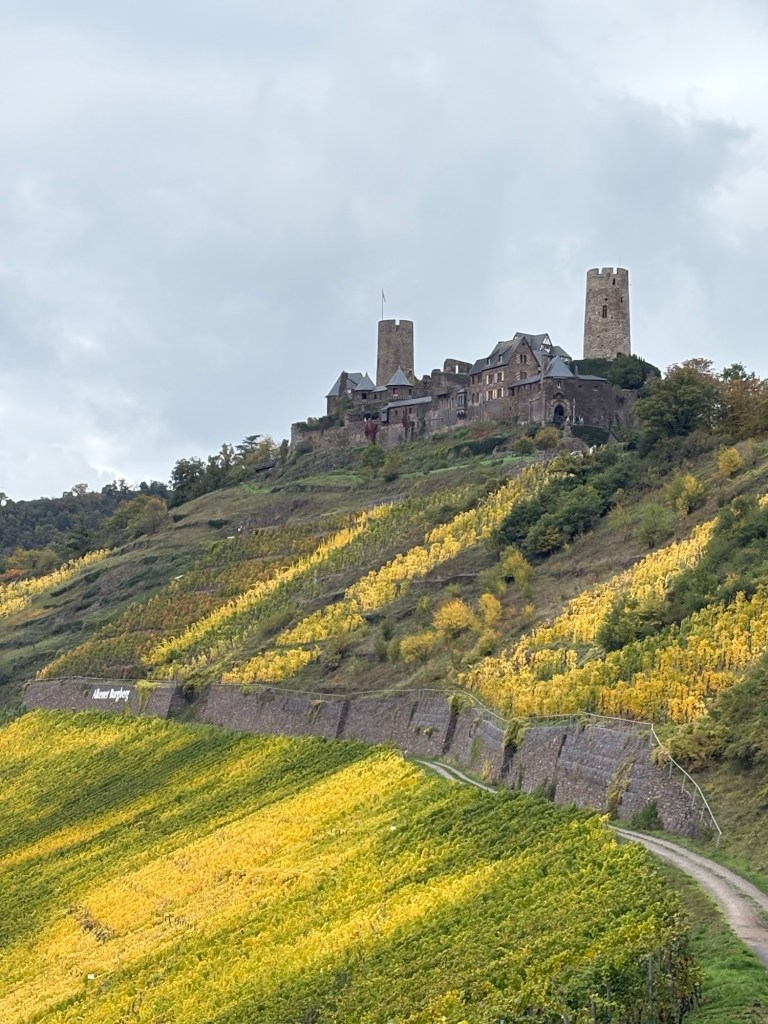
After crossing a field, I head down into the centre of Löf and pick up the trail just before crossing the bridge that will lead me to the right bank of the Moselle for the first time since leaving Cochem. A friendly local gives me a bit of advice about a possible shortcut on the climb to Burg Thurant, the huge castle looming over the vineyards on the opposite bank of the Moselle, but I first need to stop to get some lunch before heading up there.
Luckily, across the bridge and just outside the village of Alken, there’s a huge Edeka supermarket a short distance from the trail. I veer off to buy a sandwich from the supermarket’s bakery, along with a couple of bars of chocolate, then begin the day’s third climb, up to Burg Thurant. This one isn’t too steep and rises gently through the vineyards. Just below the castle, I find a bench where I sit to eat lunch, partly in the sunshine that breaks through now and then, watching the traffic on the river below.
Burg Thurant is quite a sight. Perched high above the Moselle, it dates from the 13th century with vineyards below it running down to Alken and the river. It is in fact made up of two castles that belonged, respectively, to the Archbishops of Cologne and Trier. The double castle fell into disrepair in the 16th century and it wasn’t until 1911 that any restoration work began on it. It is now in private hands and is open to visitors.
After eating my lunch, rather than follow the short-cut recommended by the man in Löf, which is a continuation of the track below the castle where I’ve been resting, I follow the Moselsteig signs up to the castle itself, climbing steeply through the vineyards and a small wood before reaching the castle entrance. I decide to skip the guided tour, even though there are fewer crowds than at Burg Eltz the day before, as I still have another 14 km or so to cover.
From the castle (even more impressive from just below the walls), the trail descends to the small St Michael chapel on the outskirts of Alken, a pretty spot with a small charnel house packed with human bones just outside.
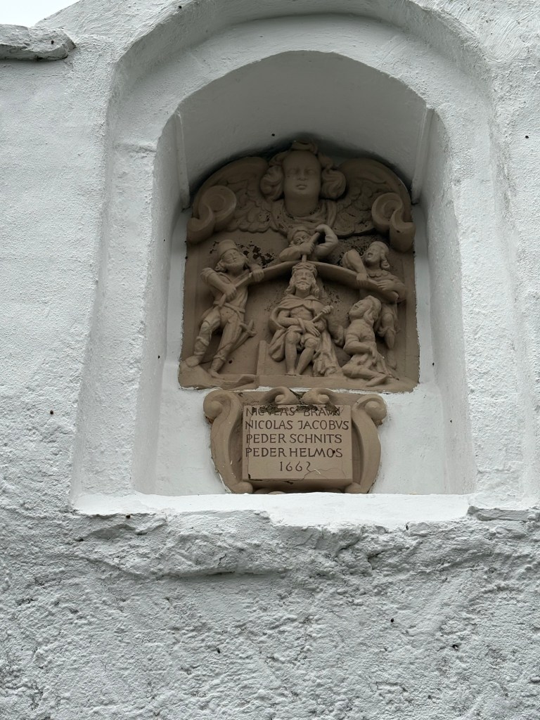
And, from there, I begin the day’s fourth climb, a steep two-hundred metre ascent from the valley that the chapel stands in to a pilgrimage church on the Bleidenberg, the hill above it, following the Stations of the Cross. I forgot to mention earlier that many of the steep climbs in this very Catholic part of Germany have followed similar paths, with the 14 stations marked by small shrines. This one is particularly interesting as each shrine features what seem to be the names of locals from the 17th century. In any case, their faith must have been put to the test on a path like this one, which is particularly steep.
It’s a relief to reach the top, look back down at Alken and see how far I’ve climbed over such a short distance.
There are also fine views of the other side of Burg Thurant from the Bleidenberg with the two halves of the double castle clearly visible.

And, of course, after climbing 200 metres and crossing some agricultural land, it’s time to head down 200 through the woods, just a little less steeply, to the edge of the village of Oberfell. The descent is pleasant enough, but the sheer number of autumn leaves underfoot could make it more slippery in wet weather.
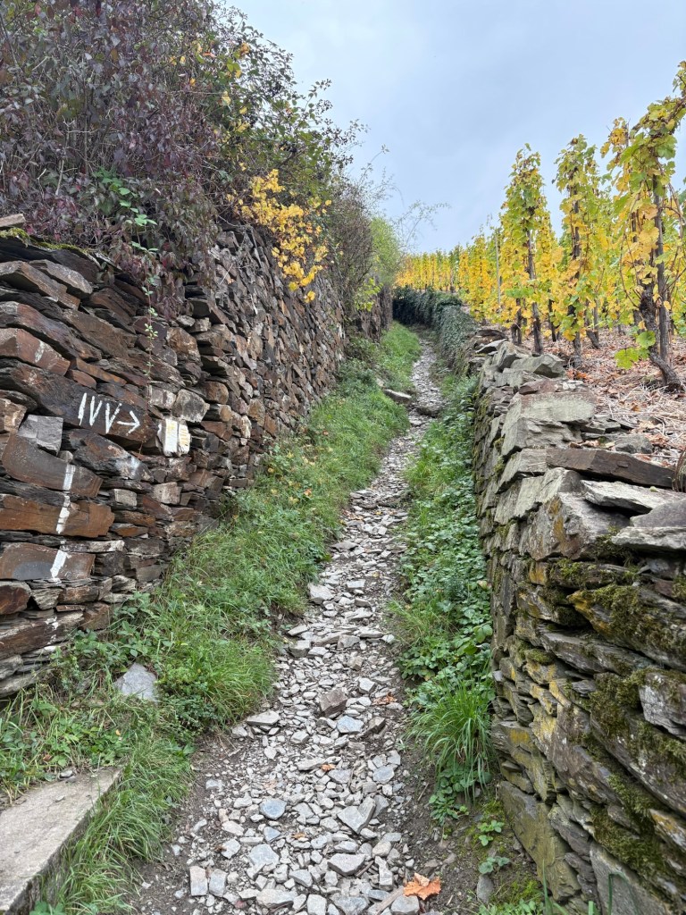
The trail doesn’t go into Oberfell itself, but immediately heads up the opposite side of the valley through the vineyards along a very steep and stony track to climb up 250 metres to the woods and farmland above Oberfell and Niederfell, my destination for the day. It’s a tough climb and seems endless, possibly because it’s the last one of the day.
When I reach the top, it’s a huge relief because I know it’ll be a gentle descent from this highpoint. And the area I’m walking through is particularly pleasant, despite the chilly wind. A month ago, the numerous apple trees would have been heavy with fruit, the woods are a delight to walk through (despite some logging that shatters the peace and quiet) and the open fields provide fine views of the other side of the Moselle valley.
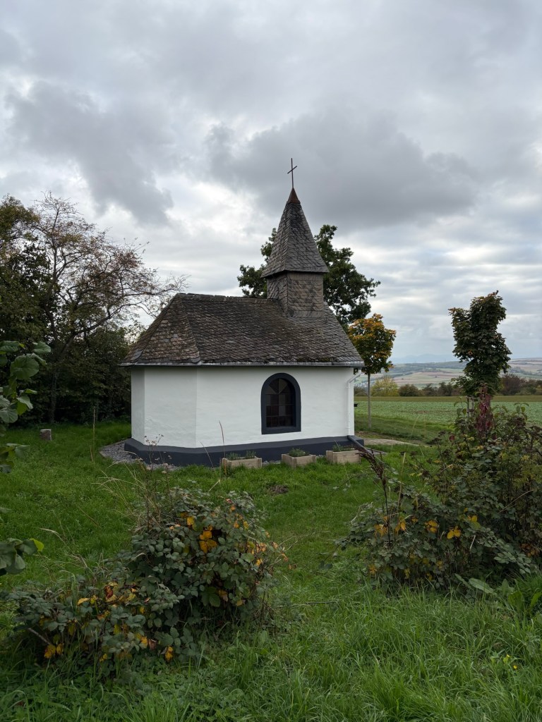
At a pretty little chapel, the Röderkapelle, the trail takes a sharp left to head down to Neiderfell.
Shortly after, at a trail intersection, I head off along the wrong path. When I realize my mistake, I decide to carry on as, on the map, the track I’m following seems to join the official trail a little further on. Unfortunately, when I get to the spot where I hope to rejoin the trail, some impenetrable woods and a steep gully prevent me from reaching it. So I have to turn back to the spot where I went wrong, a detour of about 1.5 km in all. Not ideal towards the end of a long day…
After crossing another expanse of farmland and a small wood, for the final descent to Niederfell, I leave the official trail which would take me straight to the bridge across the Moselle to Gondorf. As I’m staying on this side of the river, it’s wiser to follow the quiet road down into Niederfell, which lies about 500 m south of the bridge. It’s a pretty little village, fairly peaceful away from the main road, with lots of wine producers and kids playing on the streets.
I soon find my hotel as it’s above the quaint local cake-shop, the Cafe-Konditorei Sandler, run by some of the friendliest people encountered since I set off from Cochem. After this long day, a 27-km hike with 1,000 metres of positive elevation, a tasty slice of cake and a hot cup of tea are more than welcome before heading up to my very comfortable room.
I go back out for dinner later that evening. Niederfell has a small restaurant with a great reputation, but the place is unfortunately full this evening, so I end up at the Bella Italia Pizzeria (run by an Indian family) for a rather intriguing pizza on what I suspect is a deep-frozen, industrially-produced base. Still, as comfort food goes after a tough day, it’s hard to beat.

Some great views!
Typo alert, by the way. In your penultimate para, you talk about a 17km hike, and thus do yourself out of 10 heard-earned kilometres, if I understand things aright.
LikeLike
Thank you for that! Duly corrected. Especially as the last ten included the toughest climb.
LikeLiked by 1 person