With the exception of a couple of trails in the Fontainebleau Forest, there is one hike that I’ve done more often than any other. It lies in the heart of the Bernese Oberland in Switzerland, an area where I’ve spent many holidays, alone, with my family, with one of my children or with my wife. The hike in question, from Schynige Platte to First, is a magnificent mountain trail with terrific views of the area’s lakes and its three iconic peaks, the Eiger, the Mönch and the Jungfrau. It’s the ideal introduction to hiking around the 2,000-metre line.
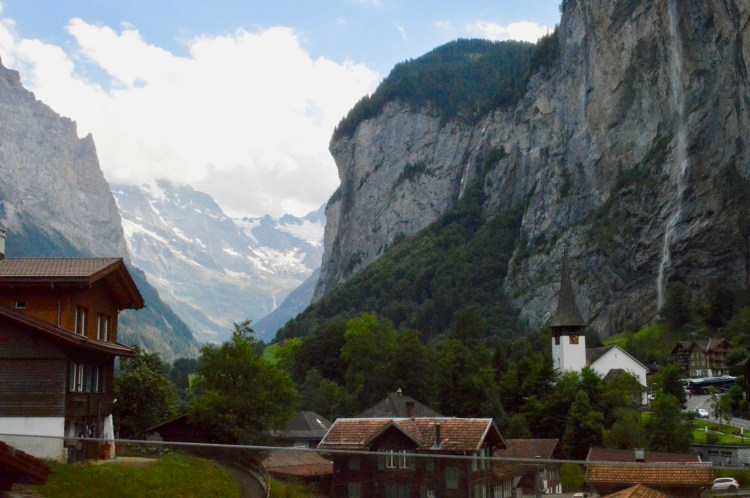
I first discovered the Bernese Oberland thanks to Eurocamp, a British tent rental company that I worked for in 1982 and 1983 for the summer season. The company had large, family-size tents installed on various camp sites around Europe and my job was to welcome customers, provide information (and a little entertainment) and clean the tents after each stay for the next booking. At the end of the season, we would travel around the different sites in the area to take down the tents and stow all the gear for the winter. As I had been on a site in French-speaking Switzerland, near Vevey, for my second season, I was on the central European crew for “démontage” as they called it. I remember that we arrived at the Lauterbrunnen site in the heart of the Oberland, just south of Interlaken, after dark and in the middle of a terrific thunderstorm. I’ll never forget waking the next morning as the sun rose and the mist lifted to reveal the setting that we found ourselves in.
The Lauterbrunnen Valley is a classic glacial valley with towering cliffs and peaks on either side of it. There are two car-free villages (Wengen and Mürren) perched on the cliffs above the valley, which can only be reached by rack-and-pinion train or cable-car (or on foot). There are a few waterfalls that flow continuously from the cliff edges, but they are multiplied tenfold after heavy rain. It is one of the most spectacular spots I know in Europe. Since 1983, I’ve been back numerous times and it’s still one of my favourite areas for hiking.
It goes without saying that hiking in this area is simply out of this world. The trails are well-marked and often challenging (the Meiringen to Gstaad traverse of the Oberland is a stunner). The excellent transport options (trains, buses, boats and cable-cars) are well-coordinated and mean that it’s possible to get around easily without a car.
And these transport options are what make the Schynige Platte to First hike such a practical proposition for a great day in the mountains, wherever you’re staying in the area. And if you’re not keen on the idea of getting the first train in the morning to Schynige Platte, there’s always the option of travelling up the previous afternoon and of spending the night at the summit hotel. I did that once, at the start of a seven-day circular hike around the Laterbrunnen Valley, and it’s a great experience in good weather as the sunset over the Thunersee below is spectacular. It also allows you to make an early start from Schynige Platte and beat the crowds. The trail is a popular one and many locals walk it as a day excursion.
All the same, there’s a certain thrill to taking an early morning train from Wilderswil. If you’re staying in Mürren or Wengen, this can mean getting up at 5 am in summer, before it’s light, to get down there on time. On a good day, the atmosphere can be incredible – a chill in the air, mist in the valley, tons of waterfalls if it rained the night before and the first glow of the new day over the mighty peaks. Despite the early hour, you’ll often find that the train waiting for you in Wilderswil is packed with eager hikers.
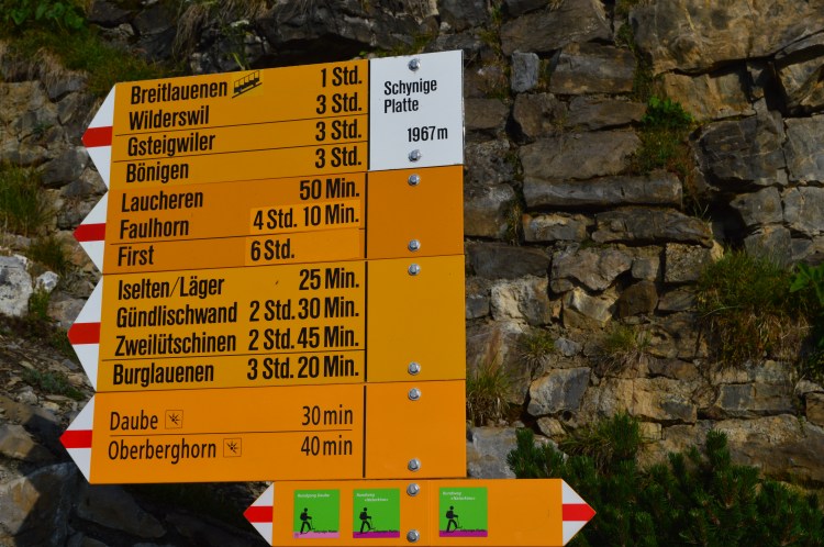
It takes 50 minutes for the train to climb the 1420 metres to Schynige Platte and there are terrific views of Interlaken and the emerald Brienzersee through the trees as it trundles its way up. After the mid-station of Breitlauenen, the trees are replaced by Alpine meadows and rockier terrain, along with a few tunnels. And, then, all of a sudden, the train rounds one last rock and reaches the final stop at 1967 metres.
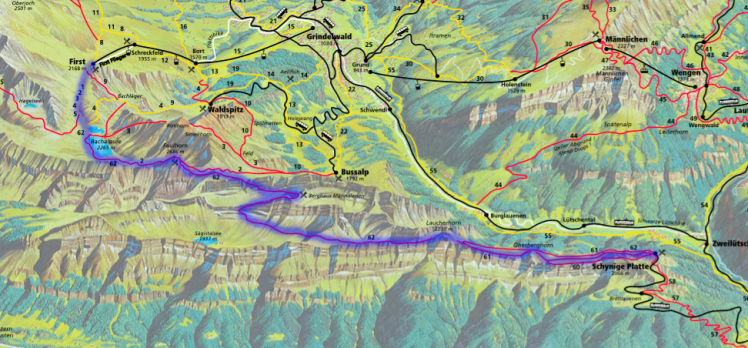
The well-marked trail starts from the station platform, with an initial choice to make between the Panoramaweg that follows the ridge overlooking Lake Brienz, via the Oberberghorn, and the direct route across the pastures. On a good day, the former is clearly the one to take as the views are fantastic. If it’s misty or raining, the pasture route is probably the better option.
The two trails meet up again before rounding the base of the Laucherhorn. Shortly after, the trail begins to rise along the right flank of the Sägistal, with a terrific view of the valley’s small lake below and, beyond it, the emerald green of Lake Brienz. This is one of my favourite sections of the trail.
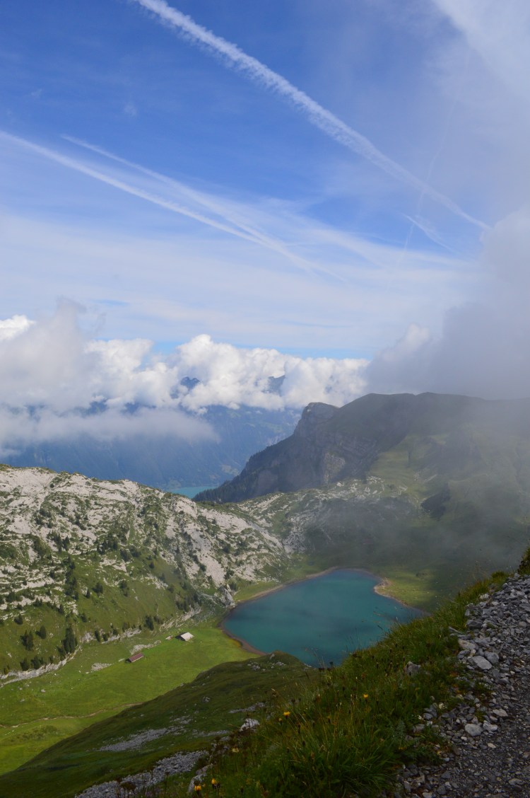
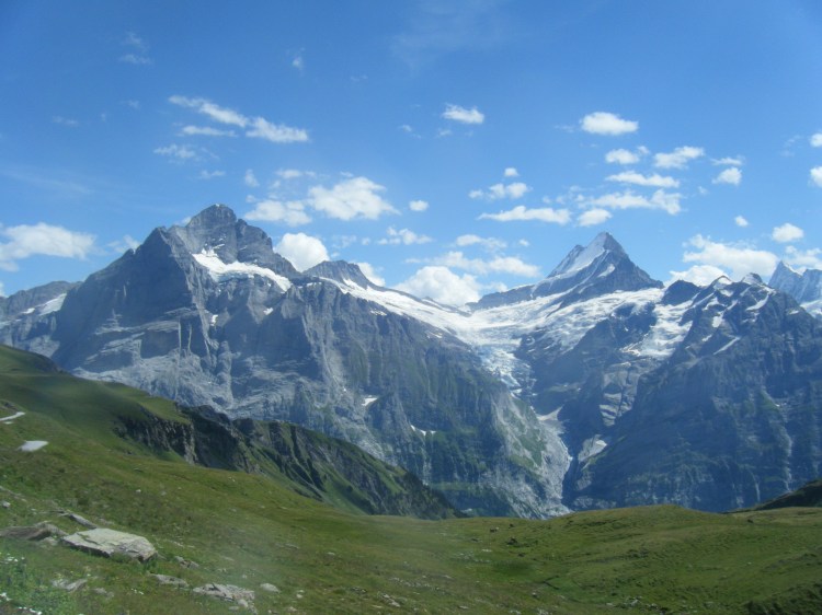
After some steep steps at the head of the valley and a fairly rocky section, there’s a possible rest stop for a refreshing drink or lunch at the Weber Hut. A rest stop isn’t a bad idea as the section after the hut is one of the steepest of the whole trail with a climb (with fixed chains) to the ridge above that provides some fantastic views of the peaks above Grindelwald and the Eiger, Mönch and Jungfrau in all their glory.

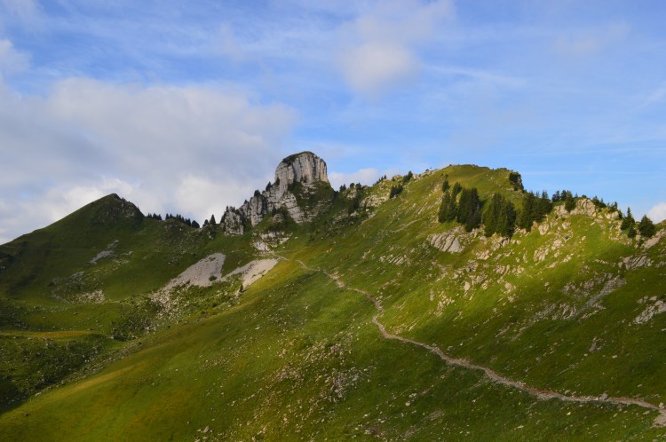
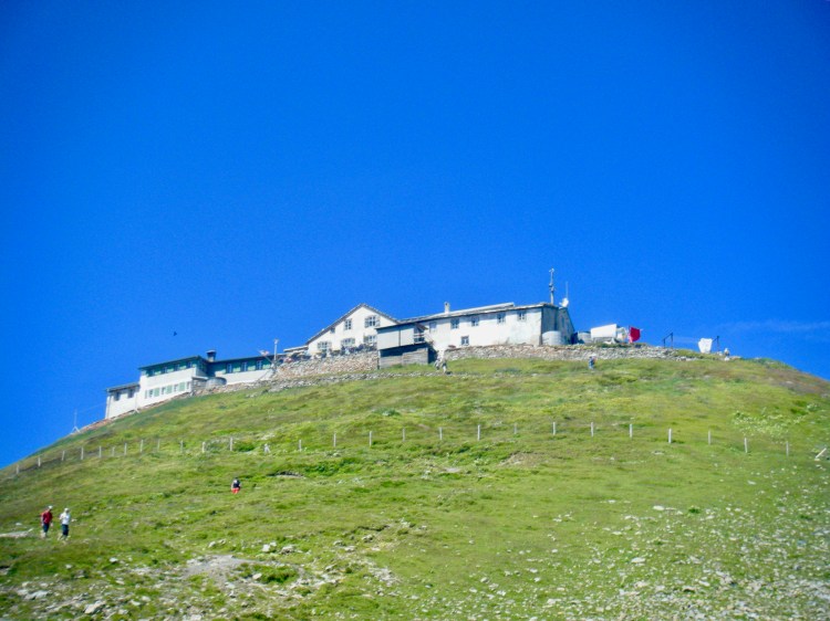
The trail then remains at an altitude of between 2400 and 2550 metres as it winds its way to the Faulhorn, a pyramid-like peak capped by a basic hotel and a restaurant with amazing views over the whole of the Oberland. Here, there is the option of going up to the top or of taking the path that skirts the base of the Faulhorn. Once again, on a good day, this peak is well worth climbing for the views.
From the Faulhorn, the trail heads down, fairly steeply at times, over slabs of rock and then a broader path, to the Bachsee with its views of the whole chain above Grindelwald. This is where the large numbers of people doing the day hike encounter those who have walked an hour or so from the First station to the lake. As a result, from this point on, the path can be pretty crowded on a sunny day.
Near the shore of the lake, there are a couple of good spots for soaking tired feet in the cold mountain water, in streams or the lake itself, for a quick boost before covering the last few kilometres.

From the Bachsee, it’s a very easy walk along the last section to First, with spectacular views all the way of the range directly above Grindelwald. There are often a number of paragliders in the sky above the valley and they make for a great show as you head along.
On arriving at First, before heading down to Grindelwald by the gondola, there’s a terrace with good coffee and cakes as a reward for completing the hike as you gaze at the panorama of snow-capped peaks.
Down in Grindelwald, you need to walk across the town to return to the railway station from the gondola. From the station, there are connections to the whole area, including the possibility of returning to Wengen or Lauterbrunnen via the Kleine Scheidegg at the foot of the North Wall of the Eiger, which makes a terrific end to a great day. Or, if you arrive early enough, you can take another gondola up to Männlichen from the lower part of Grindelwald and then take the cable-car down into Wengen from the ridge, followed by a train to Lauterbrunnen. All these different transport options are included in the regional transport pass , which is pretty expensive, true, but quickly pays for itself over the course of a week and opens up a whole range of possibilities.
I’ve done this hike three or four times already and I’m sure it’s one that I’ll return to, like an old friend, in the future.
