On the morning of July 23rd, 2021, after a great breakfast at the B&B where the owner’s sister told us all kinds of stories about her family of mountaineers (such as her grandfather celebrating his 80th birthday on the summit of Grossglockner with the whole family), we took the 9:30 bus from the centre of Heiligenblut to the start of the trail at Franz Josefs Höhe.
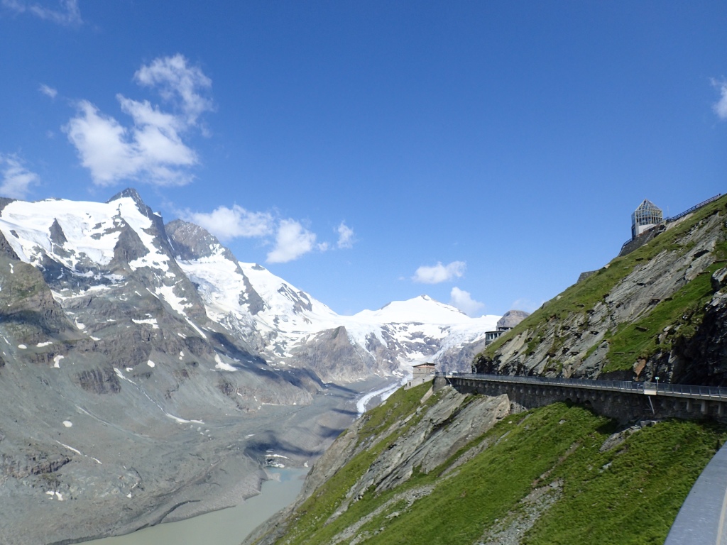
The road up is very spectacular, apparently Austria’s third most popular tourist attraction. As we went higher, we were able to make out Grossglockner in all its glory. It’s hard to figure out why this summit doesn’t feature among the iconic peaks of the Alps such as the Matterhorn because it has a very distinctive pointy shape.
From the spot where the bus left us, we had about a kilometre to walk to the actual start of the trail. Along the way, they were some very tame marmots being fed carrots by tourists. It was good to see these animals because they’re proof that you’re at a high altitude, but I couldn’t help thinking that carrots would not be their normal fare up here. The others that we saw, or rather heard, later in the day were much more authentic.
After checking in with the Alpe-Adria app at the information post (something that we would do all the way along to obtain a set of souvenirs on completing the trail), we began the hike proper with a rocky descent to the glacier lake. A friendly German girl pointed out some ibex on the way. We also passed a couple of signs indicating the position of the glacier in 1960 and in 1980 to show the extent to which it has receded since then. A very sobering reminder of climate change.
The hiking wasn’t exactly easy for a first day. The terrain was rocky, steep at times, and we really had to focus on where we were putting our feet. Definitely not a trail for beginners. That said, we were in a magnificent natural setting with snowy peaks all around, lakes formed by the melting glacier and a great little suspension bridge to cross over the raging torrent flowing from one of the lakes.
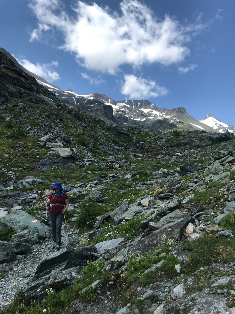

From the final lake, with its two dam walls, we followed a narrow, occasionally steep and often slippery trail high above a valley before descending along the side of the spectacular Leiterfall waterfall. Unfortunately, because of the angle of the sun at the time we passed, it was impossible to get a decent photo of this magnificent sight. Here too, the trail required a high degree of concentration because of all the tree roots and loose stones. It was tough on the knees and thighs too and, at one point, when we stopped for a brief rest, I had the impression my thigh muscles were dancing a jig of their own accord.
At the end of this descent, we found ourselves on more even terrain as we approached the Bricciuskapelle. Briccius was a crusader and, according to legend, three ears of wheat growing out of the snow on this spot showed where his body was lying. These ears of wheat feature on the coat of arms of Heiligenblut and we had seen Briccius’ tomb the previous day in the beautiful and intriguingly constructed church in the town. The waters from the spring that flows beneath the chapel are said to be beneficial for all eye ailments. I don’t know about that, but the cool water was very refreshing as the day was turning muggy with a thunderstorm threatening.

From the chapel, the rest of the day’s hiking was fairly easy. We stopped off at the Sattelalm dairy for a refreshing apfelschorle, our favourite drink while hiking, a reviving mix of apple juice and sparkling water, before carrying on towards Heiligenblut along pleasant trails that returned us to the centre of the village just before a terrific downpour from the storm that had been brewing all afternoon.
It had been a pretty tough day and, once the storm had blown over and we had showered and relaxed for an hour or two, we climbed up the hill for a well-deserved pizza on a sunny terrace with views back over the distance covered that day.
The next morning, we finally met the charming owner of our small bed and breakfast and his delightful wife who came from Luxembourg and spoke perfect French. She and her husband were great travellers. Having been foiled twice in the last two Covid-ridden years in their attempt to trek to the Everest base camp, their next trip will be from Bremerhaven to Bergen on a cargo ship! We promised to send her a card from Trieste as proof of completing the trail.
After saying goodbye to them, we headed up into the village where we did another check-in at one of the trail information points. From there, the trail began to climb slowly through farmland, with great views back over Heiligenblut.

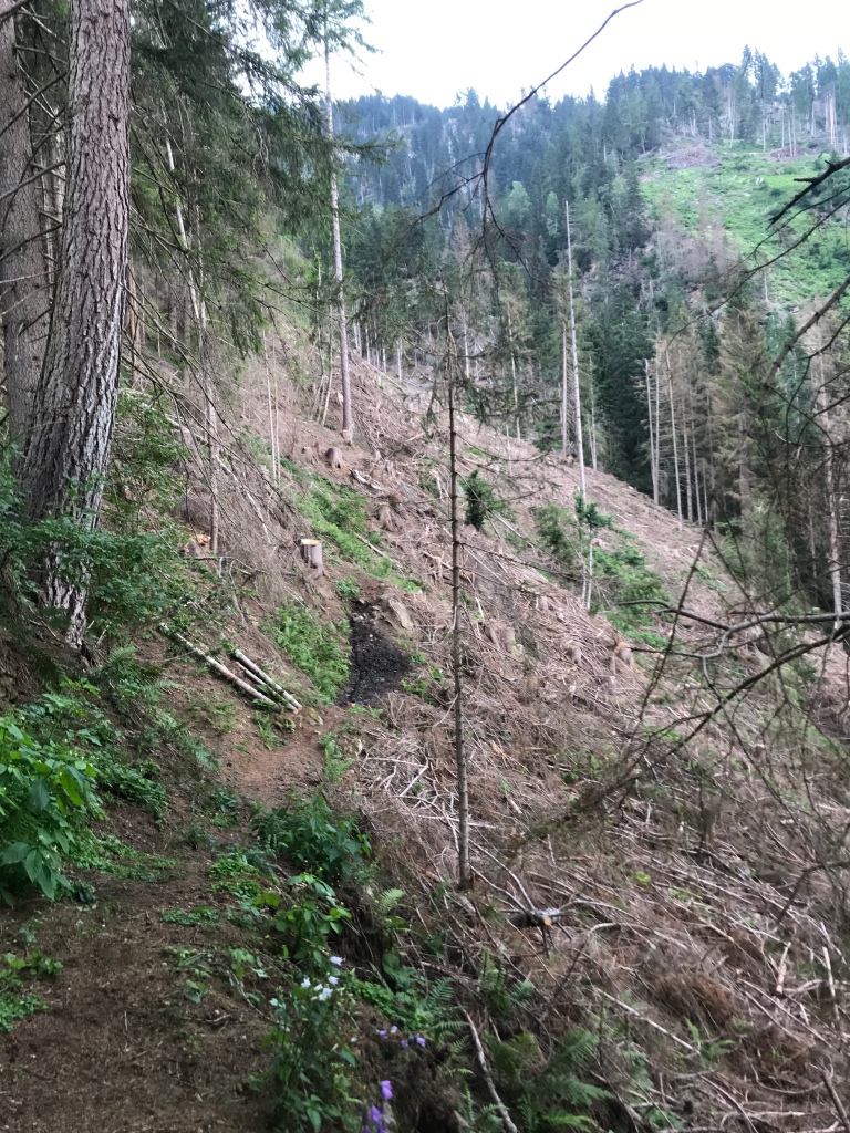
However, after a while, we came across something that would continue to crop up over the next few days: a detour from the trail because of fallen trees, landslides or logging/building work. This first detour took us further uphill, deep into a valley below the road to Franz Josefs Höhe, before crossing the mountain torrent to bring us back to the main trail, high above the valley below with terrific views of the Jungfernsprung waterfall. As it was my dad’s 86th birthday that day and because he has always liked a good waterfall, we tried giving him a video call from up there but couldn’t get through. So we had to be content with sending a birthday photo instead.

Shortly after, we met a lone hiker going in the opposite direction. He asked me what we were doing and how far we were going and when I told him, he cheerily remarked, “Only 33 more days to go!”
At times on the second day, we felt like we were walking through an open air farming museum similar to the Ballenberg one in Switzerland. There were countless old farm buildings along the trail which were clearly still being used by many of the farmers. We also saw large numbers of drying racks for hay, which would probably come into play later in the season.

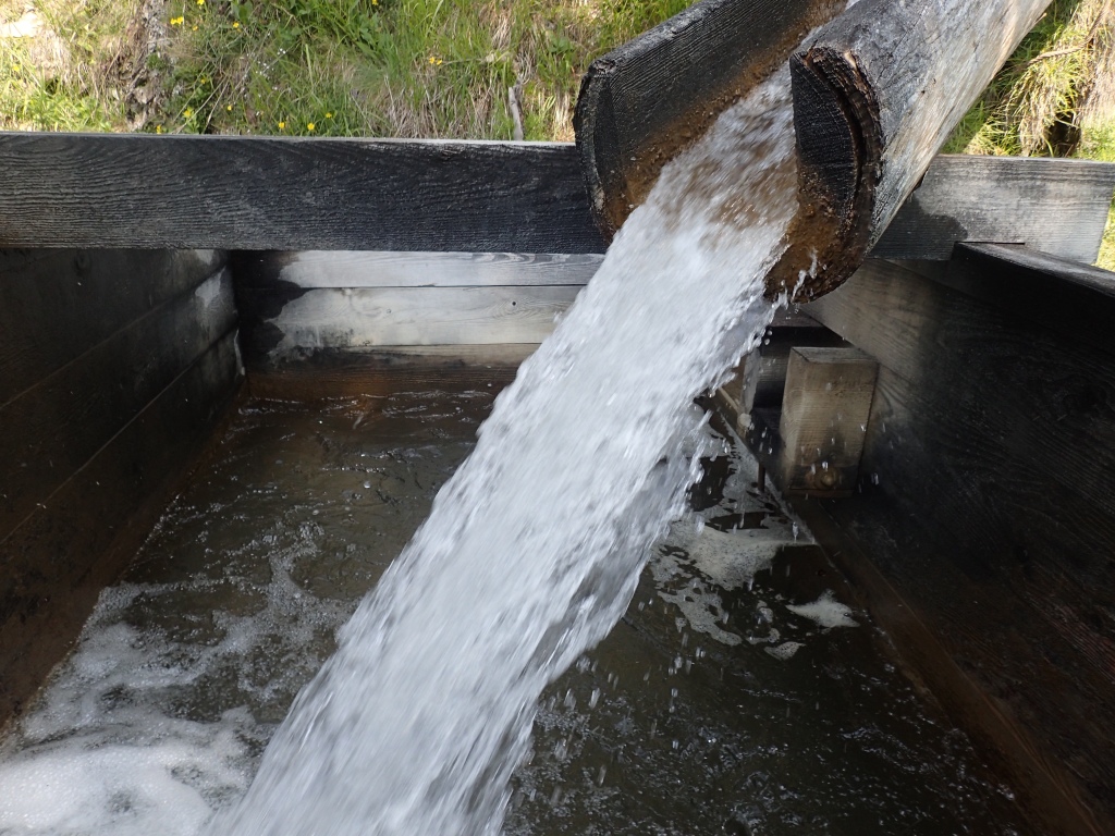
The next high point of the morning was a series of watermills at Apriach. They were built one above the other over a raging torrent that tumbled down the mountainside. There were so many of them because each local farm had its own mill. No longer used, they are now maintained as a sort of historical site.

The day was getting increasingly hot and muggy as we headed back down into the valley. This section of the trail was rarely difficult but, after yesterday’s long descent, my toes were beginning to feel slightly bruised and battered.
When we arrived in Döllach, we found the local restaurants closed. So we opted for the local supermarket where we bought cherries, ham and cheese for a picnic in the local park by the river.
After this improvised lunch, the rest of the day was a very easy walk along the valley, mostly by the river, which provided a little cool air on this very hot afternoon. At one point we had a little rain, but it didn’t last for more than five or ten minutes.
On arriving at our hotel, we simply flopped down on the terrace where the friendly owner brought us a couple of beers. Shortly after, a whole group of Slovenian hikers arrived and, about half an hour later, the heavens opened with a terrific downpour, but we didn’t care as we were safely in our room and knew that it would clear the muggy air.
It took a while to be served dinner because of the group that the staff had to deal with, but we were in no rush and the food was excellent when it finally arrived.
After breakfast the next morning, I got talking to one of the Slovenian hikers who told me that they too were walking the trail. However, unlike us, they had been doing it for the last two years every summer weekend or so. They had come from Stall the previous day and were finally going to complete the trail after two years. They seemed impressed that we should tackle it in one go and one of them asked, rather strangely, what we were planning to do if it rained. I came out with my standard retort to such a question, given to me by a Scottish ferryman years ago, “Well, the human body is waterproof.”
The day began with our first 1000-metre ascent. There had been a short climb the previous day, but this was when things began to get real. Initially, it wasn’t too tough, mostly following forest tracks and narrow mountain roads. However, at one point, at around 1500 m, we left the roads and tracks behind to head up into the woods on a rather steep trail. It was tough going, with lots of stony and rooty parts, fallen trees to negotiate and even a section with fixed cables. By the time we got to the top, we were pretty exhausted and ready for a lunch stop at the Marterle pilgrimage church at 1861 metres, the highest pilgrimage church in Austria.


There was a big crowd at the inn next to the church, but we quickly found a table with a view over the valley below. In attempting to order a salad in my poor German, we ended up with two portions of Wienerschnitzel with cabbage salad. Still, we needed the protein after the morning’s climb (and also given what awaited us further along). There was a great atmosphere at the inn, with many people having driven up there for Sunday lunch, a singer going from table to table with a guitar for traditional Austrian songs, a collection of pedigree rabbits in hutches along the side of the inn, and a free glass of schnapps at the end of the meal offered by the owner. She told me that it would help me walk a lot faster and in a straight line!

Everything had been going smoothly until this point, despite the tough climb, but shortly after leaving Marterle, we came across another detour on the trail. The descent to Stall was indicated as easy in the official guidebook, but turned out to be the exact opposite on this detour. At times, we had the impression that no one had used the trail for weeks. Given the vegetation and lack of footprints, there was no way that the 25 Slovenians from the previous evening had come this way. And, at one point, we found ourselves in a sort of landslide area with uprooted trees everywhere and a barely visible track to follow. The terrain was uneven and steeply inclined, the trail no wider than 20 cm at times and only a few scant markings on trees to indicate the way. In rainy weather, this whole section would be extremely dangerous. And even after emerging from this nightmare, the trail was as overgrown and difficult to follow as before. Looking at the map later, we realized that most hikers probably followed the road to avoid this section.
We were more than relieved when we returned to a country road that led us straight to Stall, which we could make out in the distance. We were pretty exhausted by now, after the morning’s long climb and then the huge effort made to stay focused on the descent. Moreover, as it had been impossible to zigzag on the way down, my toes had taken a real beating. It was agony putting one foot before the other and when I removed my boots that evening, I found that the big toenail on my left foot was a glorious shade of blue.
On arriving at our accommodation in Stall, we discovered that there was no restaurant there. However, the owner told us that if we followed the path between the bank and the post office, we would find a restaurant at the side of the main road. The idea of going there was suddenly called into question when the heavens opened and a terrific storm broke with high winds that swept away parasols in neighbouring gardens. Just as we were contemplating an evening dinner made up of energy bars and dried apricots, the storm blew over and, by the time we were ready to go out, the only sign of its passing were the wet streets and dripping trees.
When we arrived at the restaurant, we found it a little offputting at first, a sort of throwback to 1960s Austria. However, the waiter was extremely friendly and offered us a €12 dinner of soup with local meat ravioli in it followed by a venison stew with rice and salad. Excellent value for money.
While waiting for our food, we got talking to the only other diner in the restaurant, who turned out to be French. Emma too was planning to hike the Alpe-Adria trail, but had started to get cold feet as she was alone and had felt distinctly uneasy on the way down from Marterle. Given that the section had been described as easy and the following day’s was described as difficult, she had already decided to take the bus to the next village along the way. It was a joy talking to Emma, a 21-year-old with a very positive outlook on life who was taking time off between jobs to travel. We swapped email addresses to stay in touch and give each other tips about the trail. By keeping each other posted about our movements, we felt that we would meet up again somewhere.
And so, after a great dinner, we headed back to the guesthouse for an excellent night’s sleep.
Three days down, 31 to go!

Picturing myself ‘there’ in less than 2 months, I am loving your blog Ian. Fondly sandi
LikeLike
Ian is there any chance you could give me a hand re. reasonable accommodations at each stage of your hike? Did you pick from those listed in the Guide book? sandi
‘Because of His great Love, we are not overcome’ Bifrost Arts.
LikeLike
Hi Sandi, what sort of budget are you looking at for accommodation per night?
LikeLike
Ian thank you – I am just changing my mind about the AAT for this year. Instead I hope to be a Hospitalera at an Albergue on Camino de Santiago volunteering for 2 weeks and then walk the Camino again during my time away. Have a great hike. My husband & I are both enjoying your blog. fondly sandi
LikeLike
Hi Sandi,
Sorry I didn’t get back to you sooner. I think you’re probably right to opt for another solution. We have met very few lone hikers and there are certain sections that could prove a little risky alone. Your plans sound very interesting. Will you be passing through Paris on your way? If so, it would be wonderful to meet up.
All the best,
Ian
LikeLike